
AUV Jubilee: CONCORDE Coordinates Gulf-Wide Data Collection Event

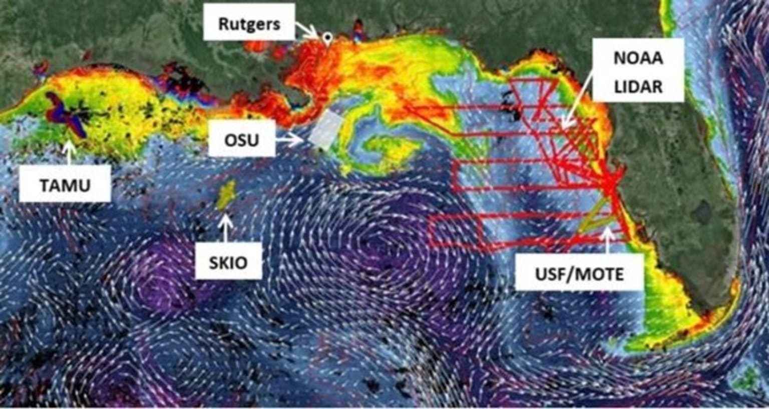
Google Earth image with VIIRS Chlorophyll and HYCOM-derived surface currents and salinity contours for July 11, 2015. Photo credit: Consortium for Oil Exposure Pathways in Coastal River-Dominated Ecosystems (CONCORDE), 2015.
A recent collaboration among Gulf of Mexico Research Initiative (GoMRI) consortia coordinated a collection of real-time data to reveal the secrets of the coastal ocean in the Gulf of Mexico. The AUV Jubilee, held July 2015, was a successful event that coordinated the deployment of autonomous underwater vehicles (AUVs or gliders) and other in situ operations in the Gulf of Mexico. The primary goal was to establish collaboration among scientists from ten institutions across the Gulf to acquire simultaneous ocean observations and create a multifaceted and integrated data set. The data collection component of the AUV Jubilee was led by the University of Southern Mississippi's Ocean Weather Laboratory (OWX), which is a part of the GoMRI-funded Consortium for Oil Exposure Pathways in Coastal River-Dominated Ecosystems (CONCORDE).
The OWX hosted a series of daily webinars from July 13-17 to display real-time ocean color and model (HYCOM/NCOM) products, as well as spatial uncertainty estimates. With this system, it is possible to examine the origin and date of river plumes, quantify biomass and physical volume transport, track the movement of bio-optical features, characterize water masses, resolve spatial and temporal variance, and link the bio-physical coupling that ultimately drives ecosystem variability on global scales. This tool enabled the display of up-to-date locations of various glider and ship/aerial operations while they were deployed and facilitated near real-time data exchanges in order to further assist in adaptive sampling. OWX provided collaborators with this data to expand the capacity and quality of data collection.
Webinar discussions held by glider pilots and other participants focused on regional oceanography (i.e., location of river filaments, eddies, high/low chlorophyll regions, surface currents), mission challenges/successes, future waypoints, data collected (via Gulf of Mexico Coastal Ocean Observing System-generated kmz files with profile data visualized in real time), and comparisons of in situ subsurface features with the surface expression as shown by Visual Infared Imaging Radiometer Suite (VIIRS) ocean color or model output. Participating glider pilots were given the opportunity to give an in-depth description of their individual missions and the ocean technology being used in these missions. Educational outreach webinars focusing on data collection and data sharing across broad collaborative groups were well-received by a group of ten highly qualified teachers from the Southeast United States.
All data collected through the AUV Jubilee will be registered with or submitted to GRIIDC. Participants were also encouraged to submit data to the National Glider Data Assembly Center (NGDAC), which is a part of the U.S. Integrated Ocean Observing System (IOOS). By submitting to the NGDAC, real-time glider data can be distributed to the Global Telecommunications System (GTS) for use in regional and global scale ocean forecasting models. The data in the NGDAC contains individual profiles, as well as trajectory and deployment data. Data is made available for public access via ERDDAP and/or THREDDS end-points, and is subsequently channeled to the GTS through the NOAA National Data Buoy Center (NDBC). Ten institutions participated in the AUV Jubilee: University of Southern Mississippi (CONCORDE), Rutgers University (CONCORDE), University of South Florida’s Mote Marine Lab, Texas A&M University, Oregon State University (LADC-GEMM), University of Georgia’s Skidaway Institute of Oceanography (ECOGIG), Gulf of Mexico Coastal Ocean Observing System, National Oceanic and Atmospheric Administration, Roffer's Ocean Fishing Forecasting Service, Inc., and Florida Fish and Wildlife Research Institute.
This research was made possible in part by a grant from BP/The Gulf of Mexico Research Initiative (GoMRI) to the Consortium for Oil Exposure Pathways in Coastal River-Dominated Ecosystems (CONCORDE). The GoMRI is a 10-year independent research program established to study the effect, and the potential associated impact, of hydrocarbon releases on the environment and public health, as well as to develop improved spill mitigation, oil detection, characterization, and remediation technologies. An independent and academic 20-member Research Board makes the funding and research direction decisions to ensure the intellectual quality, effectiveness and academic independence of the GoMRI research. All research data, findings and publications will be made publicly available. The program was established through a $500 million financial commitment from BP.